
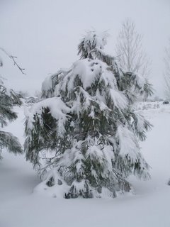
Posted 3PM December 29th: Just like the original but with new features. This is the second major blizzard in a week. This time we got a new feature with the blizzard - a power blackout. This new blizzard hit last evening and by 10 PM we had about 8 new inches on top of the old snow from before Christmas. About 9PM last night, the power went out suddenly and without a flicker. We could tell it was going to be out for a while. We scrambled to locate flashlights and candles and thought we were set for the evening.
But then I remembered that while we did fuel the car & truck before the snow started, I had neglected to get some extra fuel for the generator or for the John Deere. I got the tractor out and started plowing a path to the road and by 10 PM, was ready to go out looking for gas. Kenny and I took the SUV and drove about 6 miles south and passed by a half-dozen gas stations - all closed and all without power. We turned west toward Louisville and went a few more miles and saw no power anywhere except for a few emergency generators. By then the blizzard was ragging and the winds were blowing the snow at 30 MPH. We turned around and returned safely home empty handed. We got a few extra blankets out and decided to leave the generator off for the night (no heat).

Sometime during the night the snow stopped and the power was restored. In the morning I finished plowing the drive and went out again with Kenny for fuel (just in case). The weathermen were saying that the situation would get worse later this evening when the second wave would hit. At the first station, we found power, but the pumps were closed - no fuel! We continued on a few more miles down the road and found another station pumping the precious unleaded. We returned with a fresh five gallons of the stuff and felt ready for the next wave.
Get up to the minute weather data for our storms at this link: http://www.leyner.org/
Here is what the National Weather Service said today:
Urgent - Winter Weather Message National Weather Service Denver Co 1125 AM MST Fri Dec 29 2006 ...Heavy snow to continue today for most areas of northeast and north central Colorado... .bands of moderate to heavy snow will continue to affect the northeast plains of Colorado through this afternoon. West of interstate 25...only light snow is expected through the day. Stronger winds over the northeast plains will also cause near zero visibilities in blowing and drifting snow. North winds from 15 to 30 mph can be expected with some gusts up to 35 mph. The storm is currently centered over southwestern New Mexico and is expected to move slowly northeastward into the Texas panhandle by Sunday morning. This track will produce strong winds and heavy snowfall for the northeastern border counties of Colorado now through much of Sunday. This storm track could also produce heavy snowfall for the rest of the plains of northeast Colorado, the front range foothills and higher mountains east of the divide for much of the weekend. This includes the Denver metro area and all the urban corridor. There are still uncertainties regarding the duration of the heavy snow west of interstate 25 and whether heavy snow will redevelop near the mountains this weekend. Because of this a winter storm watch continues through Saturday night for the north central mountains and front range foothills and the plains through Sunday afternoon. All people planning to travel across northeastern and north central Colorado today through the weekend should be prepared for road closures and very difficult winter driving conditions. Roads will be icy and snow packed and blowing and drifting snow will become more of a problem on the plains with time. You are urged to avoid any unnecessary travel and carry items such as a shovel, food, water and warm clothing if you do go out. The storm has also disrupted air travel at Denver International Airport. Air travelers should check with their airlines for delayed or canceled flights.
Northwest Weld County- Boulder And Jefferson Counties below 6000 feet/West Broomfield County- including...Fort Collins... Hereford... Loveland... Nunn... Arvada... Boulder...Golden...Lakewood...Longmont 1125 AM MST Fri Dec 29 2006: Winter storm warning is cancelled… Snow and blowing snow advisory in effect until 6 am MST Saturday. Winter storm watch now in effect from Saturday morning through Sunday afternoon. The national weather service in Denver has issued a snow and blowing snow advisory, which is in effect until 6 am mst Saturday. The winter storm warning has been cancelled. The winter storm watch is in effect from Saturday morning through Sunday afternoon. The bands of heavier snow showers are expected to remain east and south of Denver. Therefore the winter storm warning has been downgraded to a snow and blowing snow advisory. Additional accumulations of 2 to 6 inches are still possible through tonight. The potential still exists additional heavy snowfall and strong winds Saturday through Sunday as the storm continues to move slowly northeastward. Additional snowfall accumulations of 6 to 12 inches will be possible over the weekend along with areas of blowing and drifting snow. A snow and blowing snow advisory means that visibilities will be limited due to a combination of falling and blowing snow. Use caution when traveling, especially in open areas. A winter storm watch means there is a potential for a hazardous winter weather event in and close to the watch area. Significant snow accumulations may occur that could impact travel. Stay tuned to the national weather service or your local news media for the latest updates and possible warning concerning this potential winter storm.


1 comment:
Wow, that is a lot of snow. I would never have had the courage to go hunt for gasoline! We had thunderstroms and several tornados here in Central Texas today. What strange weather. Love your blog.
Post a Comment